
Future NZ roading costs due to sea-level rise
Roading infrastructure is critical to our social and economic wellbeing. In coastal areas, sea-level rise, often combined with land sinking through vertical land motion, means that some road networks are at risk from sporadic flooding during severe events and/or permanent inundation.
RiskScape was employed to evaluate roads exposed to flooding, calculate losses every 10m2 across the exposed road network and enumerate losses by region.
The team calculated losses from extreme events (which are less frequent but more damaging) and average annual losses expected from all flooding events between 2020 and 2120. They used local sea-level rise projections that also accounted for land sinking or rising, and looked at a range of global scenarios for future greenhouse gas emissions.
They found that factoring in vertical land movement meant the impacts of sea-level rise could be felt 10-20 years sooner in areas where land is sinking and up to five years later in places where it is rising, compared with looking at just sea-level rise alone. This means that some locations could face expensive damages much sooner than expected. Unsurprisingly, under the higher emissions pathway, costs increased faster and earlier than under lower emissions pathways.
“The model used in this study could help identify which parts of the road network are most at risk in the future and evaluate which adaptation strategies – like building stronger infrastructure or changing how roads are used – might work best as sea levels rise.”
The work highlighted uneven economic risk across the country, with some areas – including Wellington and parts of the South Island – more exposed due to proximity to the coast and/or faster land sinking. The researchers say this finding emphasises that local land changes should be built into planning and risk assessment to avoid underestimating future damage.
The spatiotemporal model used in this study is flexible and can be adapted for other types of critical infrastructure. It can also integrate more detailed data, such as bridge vulnerability or traffic disruptions, to improve accuracy. The researchers say that for even better predictions, future work could validate results against real-world flood damage or expert insights from past events.

National projections of combined direct economic average annual loss (AAL) for road class exposure episodic coastal flooding
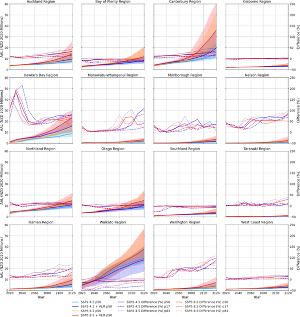
Regional projections of combined direct economic average annual loss (AAL) for road class exposure episodic coastal flooding
Data availability: The datasets generated during and/or analysed during the current study are available from the corresponding author upon reasonable request. GIS data for the New Zealand road network is available on request to the New Zealand Transport Agency (https://www.nzta.govt.nz/about-us/open-data/national-road-centreline-data-request). New Zealand relative sea level rise projections for Shared Socioeconomic Pathways (SSPs) are available at https://searise.takiwa.co/